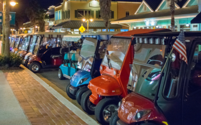
Rocky Mountain Tracking

Daily GPS News

An Update On OR-7

May 17th, 2013

OR-7, also known as “The Lone Wolf,” is still wandering the wilderness, being tracked via GPS tracking collar. We’ve provided updates along his journey, and will continue to do so until he can be tracked no more. It seems the famous gray wolf has crossed Interstate 5 a total of two times in the past few months.


For the past six weeks, the 4-year-old wolf has been meandering his way in and out of Jackson County, occasionally heading into the eastern portion of Douglas County, and then heading back for a short while to California, where he had his first I-5 crossing experience.


The GPS tracking collar shows the wolf crossing the Interstate near Yreka, CA which is in the northern portion of the state. This is the farthest west the wolf has ever traveled in the entire 19 months he’s been wearing the GPS tracking device, according to US Fish and Wildlife Service reps.


After crossing I-5, he turned around and headed the way he came, again crossing the Interstate. John Stephenson, a USFWS biologist who’s responsible for watching OR-7 move about the area from the comforts of his Bend, OR office said, “Hopefully, he’ll stop doing that. That’s not a good strategy for longevity.”


He trekked north again according to the Oregon Department of Fish and Wildlife, heading into the southeastern part of Jackson County and the hills to the south of Emigrant Lake just east of Ashland.


OR-7 is the only known gray wolf ambling about California since 1924. And when he is in Oregon, he is the first known gray wolf residing west of the Cascades ever since the last one was killed in order to protect livestock in the area back in 1937.


Mark Vargas is with the Oregon Department of Fish and Wildlife’s Rogue District, working as a wildlife biologist. He said, “Man, that wolf can travel. The distances he’s covering is amazing. He could be back in Siskiyou County (California) as we speak.”


OR-7 has been traveling from Oregon to California and back again last spring as well, in his quest to find a place to call home and a mate. He ended up almost in Nevada, at which point he turned around and walked all the way back. Vargas says, “Who knows where he’s going.”


You can be sure we will keep you up to date as to the movements of this great creature. The entire world seems to be watching, too: his story has been covered in a total of five continents.

Lawmakers Trying to Limit The Use of GPS Tracking By Law Enforcement

May 17th, 2013

Legislation was introduced by a bipartisan group of lawmakers from both the House and the Senate that requires police to obtain a warrant prior to collecting data from a suspect’s tablet, cellphone, car, or any other electronic device.


The Geolocation Privacy and Surveillance (GPS) Act addresses both location records held by cellphone service providers and real-time tracking of people as they move about town.


A total of 9 representatives in the House along with two senators brought the bills forward respectively. Among them: representatives Jason Chaffetz, John Conyers, and Jim Sensenbrenner, and Senators Ron Wyden an Mark Kirk.


This legislation will not only require a warrant: it will also deem illegal the use of any electronic device to track a person’s location covertly. This part of the bill addresses the problem of the jealous boyfriend who tracks his girlfriend with an app he secretly installs on her iPhone. It also relates to companies as well, requiring their employees to grant permission to gather GPS location data.


“New technologies are making it increasingly easy to track and log the location of individuals. We need to make sure laws are keeping up with technology to protect our privacy,” said Chaffetz. “Put simply, the government and law enforcement should not be able to track somebody indefinitely without their knowledge or consent or without obtaining a probable cause warrant from a judge.”


Wyden agrees: “The GPS Act provides law enforcement with a clear mandate for when to obtain a warrant for the geolocation information of an American…It also provides much-needed legal clarity for commercial service providers who often struggle to balance the privacy of their customers with requests for information from law enforcement. Finally, it protects the privacy and civil liberty of any American using a GPS-enabled device.”


There is an exception: the bill allows GPS tracking in emergency situations or issues of national security.

GPS Device Helped Land D.C. Shooting Suspect In Jail

May 17th, 2013

A 19-year-old man was connected to the horrific mass shooting on North Capitol Street in Washington D.C. in early March thanks to the court appointed GPS tracking ankle bracelet, according to court documents.


That’s right: the suspect, Craig Steven Wilson of Southeast Washington, was wearing a GPS monitoring bracelet. In D.C. Superior Court, the judge asked that he be detained until the date of his next hearing, even though he was already under court supervision.


Wilson, upon his arrest, was charged with assault with intent to kill after the March 11 shooting, which wounded 13 people, one of whom is listed in critical condition, outside of an apartment high-rise off New York Avenue.


Although court documents state how the suspect was caught, no motive is given as to why Wilson opened fire that morning at approximately 2:10 in the morning. The surveillance video shows the barrage of gunfire and victims hitting the ground, leaving residents in the 1200 block of North Capitol Street NW quite uneasy. It is also near to NoMa, which is an up-and-coming area for upscale shopping and residents.


One of the two cars used in the shooting belonged to Wilson, which they determined through viewing security cameras and obtaining the license plate number.


Upon learning his identity, they checked out the location data on his GPS tracking bracelet: it placed him two blocks from the shooting scene at approximately one hour prior to the shooting. When they looked at further GPS location data, they “watched” him circle the block for over an hour, culminating in him speeding past the building and opening fire.


In 2012, D.C. Superior Court mandated GPS monitoring for 1,351 defendants; 110 of those were arrested thanks to the device and charged with new crimes. 11 of them involved violence.


It is clear that GPS monitoring of criminals is an important step to holding them accountable for any future actions they might commit, as well as providing rock solid evidence placing them at the scene of a crime.

Sports Watch Meets GPS Tracking Device

May 15th, 2013

If you’re a gadget person, or even if you’re not, you’ll have to admit this latest addition to the GPS tracking device market is pretty cool. The Switch series watches for athletes, the newest crossover navigational tool is being premiered in Europe. This handy piece of technology not only tells you where you are and how to get to where you want to go, but also helps you meet your fitness performance goals.


Fitness Watch/Training Tool

This combination watch and GPS tracking device is tailored especially for those who participate in outdoor sports such as running, swimming, biking and other related activities. It’s available through select retailers and, of course, the European distribution network. The Switch and Switch Up watches record performance data for multisport athletes, who may also upload and track their data online using metrics, maps and intuitive charts– all from one spot on the globe.


Stay on Target

Runners will find this crossover watch/GPS especially useful. It includes such innovative features as an “Activity Pacer” which monitors whether the runner is on track with the goal and offers specific targets to get the desired result. As a navigational tool, it allows you to mark and save locations and navigate back to an original spot. You can also configure calories spent based on time, heart rate, speed and distance. Nine customizable sport profiles add to the watch’s appeal.


Bonus Features

If you choose the Switch Up watch, you get a fully loaded product that, in addition to all the features on the Switch watch, also tells you temperature and barometric pressure. Other available accessories include a quick release mount for wrist and bike to allow for easy transition between activities. If you need more than eight hours of battery life, you can buy the optional battery extender pack.


Athlete Friendly

You can tell that this fitness tool is designed for active people: it has an easy-to-read, high resolution display to increase its visibility on the run. The battery’s endurance is eight hours, making its power last as long as the activity. The GPS receiver is highly sensitive so you can depend on its accuracy. Going for a swim, or participating in a triathlon? That should be no problem for the Switch: it is water resistant to 50 meters. It is also compatible with ANT+ sensors, so you can coordinate it with your other technology. This clever sports watch, with its wide range of appeal should be a good fit for many.

Stiffer Penalties Await Parolee’s Tampering with GPS Devices

May 15th, 2013

It seems that California’s overcrowded prison system can’t win. Gang violence has long been a problem for cities like L.A., Oakland, San Jose, and the Iron Triangle district of Richmond, which have all earned well deserved reputations as some of the nation’s most dangerous areas. And the economic downturn of the last decade certainly has not helped curb the violence as cities forced to make cuts have trimmed police forces as well as after school programs that help keep kids of the streets.


Ongoing violence and the felons convicted under the three strikes law have contributed to a rapidly burgeoning state prison system. Hoping to relieve some of the burden on the prison system, the California legislature enacted AB 109, a law which downgraded parole violations from a state prison offense to a county prison offense. While the bill may have seemed like a good idea, it was only a matter of time before criminals discovered how to use it to their advantage.


With the punishment for parole violations now less severe than before, parolees with GPS bracelets attached to them became more brazen in their attempts to rid themselves of their tracking devices and slip through the hands of the law. In the 15 months before AB 109 was enacted, only 221 state parolees tampered with their GPS tracking device, according to state Senator Ted Lieu, who is leading an effort to amend the bill. In the same time period since the bill was passed, 482 parolees attempted to break or cut off their GPS tracking bracelet, and that number can only be expected to grow as stories of success trickle through the criminal underworld.


Senator Lieu’s new bill, labeled SB 57, would give judges the authority to have parolees found guilty of tampering with the GPS tracking device sent to state prison for up to three years, essentially making the crime a federal offense. GPS tracking devices have proven very useful to law enforcement in recent years, allowing them to keep a close on former cons being reintroduced to society and providing accountability for minor offenders in need of a reminder to behave.  With crime on the rise, now is the time to be cracking down on known offenders trying to skirt the law again, not handing out lighter sentences. If tampering with GPS tracking devices is once again made punishable by a significant length of time in state prison, the number of parolee’s tampering with their devices will dwindle allowing law enforcement officials to keep track of known criminals while still giving them time to find new offenders.

Kidnapper Tracked Down Using GPS Technology

May 13th, 2013

From recording sports data to providing directions to a destination, GPS technology has many applications to everyday life. Recently, a Delaware police department put GPS to work to catch a dangerous fugitive.


The Crime

One early morning in February, Edward Thomas Johnson entered a home in North Versailles Township, violated an order of protection, assaulted his girlfriend, and kidnapped his infant son. He then left the area, leaving police with a warrant but no criminal to arrest. The North Versailles police suspected that Johnson had fled to nearby Upper Darby, so they contacted the police for that area.


The Chase

Using the GPS technology built into Johnson’s cellphone, the Upper Darby police obtained geographic coordinates for his location. This information verified that the fugitive was indeed hiding in Upper Darby, but that left quite an area to be searched. Police then took the coordinates and entered them into Google Earth. The computer program narrowed down the possible area to the 500 block of 69th Street. With this condensed search radius, about six officers began going house-to-house, knocking on doors, and asking residents if they knew Johnson.


The Capture

When officers reached one particular home, a woman came to the door. Asked if she knew Johnson, she hesitated, and then reported that he was her son and was sleeping on her couch. Police entered the residence, arrested Johnson, charged him with being a fugitive, and placed him in jail until North Versailles police could come to pick him up. The infant was also found in the home and was unharmed. The child was transported to a nearby hospital to be evaluated, placed in the temporary custody of Children and Youth Services, and eventually reunited with his mother.


This incident is a classic example of how GPS tracking technology can help police departments and other law enforcement agencies. Without the technology, police would have a lengthy search lasting days or weeks and might never have located Johnson. Instead, what could have become an extended manhunt was quickly resolved through the use of a GPS-equipped cell phone and Google Earth. With positive example like this one, it is very likely that GPS devices will play an even greater role in law enforcement in the days to come.

No Royalties for GPS Hardware

May 13th, 2013

GPS hardware will be royalty-free as a result of a recent agreement between the United States and the United Kingdom. This arrangement quells fears that US developers would be required to pay large fees to the originating company in the UK.


The Background

GPS technology has been around for a number of years and has a variety of applications. Besides its well-known use of providing driving directions, GPS devices are used in agriculture, finance, and aerospace. Satellite networks are the important framework behind GPS technology. Various networks exist including the Galileo, Glonass, and Compass networks.


The Claim

A company in the United Kingdom, Ploughshare Innovations, developed a number of GPS hardware pieces that are used in the satellite network system. This company is actually a state-owned subsidiary of the Defence Science and Technology Lab, which is the research arm of the UK Ministry of Defence. In the Spring of 2010, Ploughshare told US developers that they were asserting patent rights on various components of the satellite network. Thus, they demanded royalty payments for any sales of devices utilizing the technology.


The Argument

This claim aroused a great deal of uproar in both the US and the UK. Government officials were concerned that requiring royalty payments for the use of technology would cause US developers to come up with new systems, making it impossible for the two countries’ networks to communicate. They also cited concerns about decreased availability of GPS technology for civilian applications and even litigation that might try to recover royalties from actual users of the technology. The governments of Russia and China also expressed concern that such a move would harm their satellite networks as well.


The Agreement

The recent agreement states that GPS hardware shared by the US and UK is open-source. This term means that it is freely available to the public and no royalties can be charged. The arrangement illustrates the close relationship that exists and continues to grow between the US and the UK in matters of technology. It also emphasizes the important role that GPS technology plays in everyday life.


Although the general public may not even be aware of this agreement’s existence, its absence would likely have had major effects. The arrangement classifying Ploughshare’s GPS hardware as open-source prevents what could have been a major setback for the field.

GPS vs. the Cabbie

May 12th, 2013

Through the city they rush; what a commotion! What a hurried buzzing! Taxis, cabs; whatever you like to call them, they seem to hold a central role for residents of any big city. From point A to point B they can get you in a jiffy…usually. Sometimes they take so long you beg for divine intervention and other times they whizz past the traffic so speedily you wonder how they even manage it. Well, just maybe they used a GPS system to track a route and gauge the traffic before they even pulled out onto the road.


GPS tracking and navigation systems are tools vital to the travel, transportation, and monitoring needs of today. GPS tracking and navigation units are quickly becoming more and more commonplace in public transportation services. From airplane traffic monitoring, to public bus scheduling, to the quickest route from 42nd Street to Broadway, GPS systems are helping public transportation providers to manage their work with much more efficiency and customer satisfaction.


Many bus companies have implemented GPS systems into all of their business. This has allowed them to provide civilian bus riders with near real time bus arrival and departure times; company officials have better opportunity to monitor bus routes and stops to help their companies streamline their operations; leadership in the companies is able to monitor drivers’ behavior and to increase bus safety and security; GPS system integration can also assist companies in calculating effective means of fuel usage and savings.


Some may have wondered about the legality of the usage of GPS units in public transportation, especially as concerns cab drivers. In an interview with Business Insider, one New York cab driver had stated that it was not permissible for cab drivers to utilize GPS systems in their work. This statement was later discredited by the cab driver’s employing company, the Taxi and Limousine Commission, who stated that portable GPS units were, in fact, allowed in New York cabs.


Thinking of that conversation in light of the benefits received by various bus companies across the United States when GPS systems were implemented, it would seem that the Taxi and Limousine Commission might do better to make GPS systems an integral part of their operations. Monitoring of company operations and employees can have quite a positive effect on business.

How to Retrieve a Stolen Vehicle: GPS in Action

May 12th, 2013

There are times when concerns over a user’s privacy and security while using GPS tracking location services seem justified. Then again, there are also times wherein location services prove themselves to be the valuable tools many claim them to be. One man in particular was able to retrieve his stolen vehicle thanks to the GPS tracking location services-enabled Smartphone he had forgotten in the back seat of his SUV.


On a cold wintry morning earlier this year, an Omaha civilian man found that his SUV had been stolen from right out of his front driveway while he had been waiting inside his home while the vehicle warmed up. After calling the police, this man was informed that the authorities could do nothing directly until they had proof of the theft; the location of the missing SUV at least. This Omaha man then decided to try using a Smartphone app to try and locate his cell, remembering that he had forgotten the mobile device in the SUV before it was stolen from him. Thanks to the GPS tracking location services on his phone, this Omaha man was able to ascertain the whereabouts of his SUV. Although it was a little more worn and torn than before, his vehicle was returned to him after the police came to retrieve the thief.


Many people have discovered the usefulness of GPS tracking location services in recent years due to the application of GPS technologies in mobile devices. From laptops to Smartphones to tablets, our on the go lifestyles have necessitated portability of our technologies. Being always out and about means that we are opened to vulnerabilities with which we do not have to deal while at home. Occurrences such as theft or loss of property are many times more likely to happen while away from home.


Protection against theft is made much easier by the utilization of GPS tracking systems. Implemented in nearly every mobile technological device, location services and item retrieval apps can be turned on or off by the user at any given time. Privacy settings and security are also being upgraded continually to provide users with peace of mind about turning on the GPS tracking features on their devices. With concerns over possible privacy violations being negated further and further as technology advances, GPS tracking device users can rest easy, thankful for this little wonder of our modern age.

GPS Tracking for Water Lines

May 11th, 2013

Water authorities in Webster County, Kentucky now have GPS tracking for their water lines. With help from outside experts, the multi-step process is starting to pay off. Although the initial unit is operational, the system will require tweaking and more data entry to meet its maximum potential and usefulness. Authorities believe that the GPS system will transform the way it currently operates.


Water Line Database

The water authorities are in the process of building a database to contain all the information that employees would need to know in the field, such as the location of water lines, how deep they are entrenched, and where the nearest valves are located. This data, once collected will be accessible by GPS and therefore employees can get to it readily when they need to fix a problem.


Gathering Current Data

Current tasks for the water district employees include mapping all the existing water lines in the county. Special marking cable which is easily detected from the surface has been used in some of the newer lines, making them easy to find. Older lines are being located with the intent to map them to the GPS unit.


Informational Efficiency

Once it is fully operational, the GPS tracking on Webster County’s water lines will enable employees to locate water lines and shut off valves in just seconds. The GPS unit will provide information as to the depth of the line as well as its size and type. Shut off points will also be mapped and their nearest locations included in the data.


Future Implications

It will be interesting to see whether other counties inside and outside the state of Kentucky take Webster County’s lead to approve the use of GPS units in their water pipelines. Much will depend on exactly how much time the technology saves workmen who are trying to locate water lines and, in emergency or maintenance situations, shut off the water. Perhaps future technology will reveal the nature of problems in the pipe lines when customers call in, or maybe even control water flow from a remote location based on information gathered using the GPS unit. In any case, it is certainly a progressive step for these county water authorities to experiment with GPS tracking as it applies to water lines.

Rocky Mountain Tracking

Daily GPS News